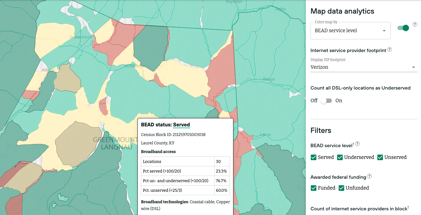
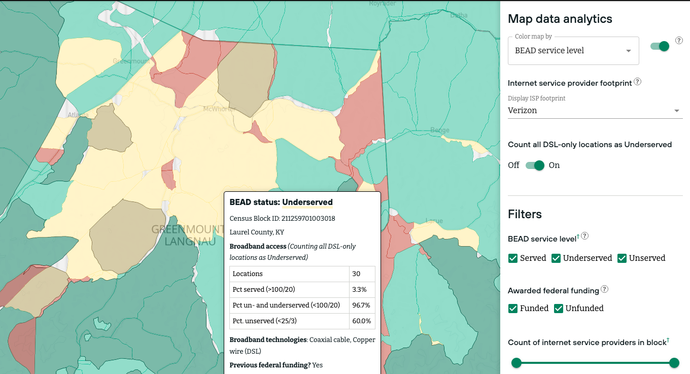
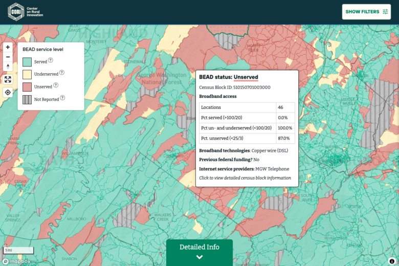
The Interactive Rural Broadband Service Map allows potential BEAD subgrantees to explore eligible project areas, view previously funded awards, and easily see existing ISP footprints in potential deployment areas. The tool is designed to support efficient initial assessments of eligibility by census block, and the creation of a high level grant strategy based on that eligibility.
Please note: This dynamic tool bases BEAD-eligible areas on the Federal Communication Commission’s Broadband Data Collection filings. While the BEAD rules require that Eligible Entities use the FCC National Broadband Map — also known as “the Fabric” — as the basis for their broadband eligibility maps, the data may diverge at the state level once Eligible Entities complete the BEAD challenge process, so please use this tool in conjunction with maps provided by your Eligible Entity after the challenge process has been completed.
At this time, the Interactive Rural Broadband Service Map defines eligibility at the census block level based on the FCC’s data. The data will be updated periodically throughout the BEAD process based on new Fabric releases.
Questions? Get in touch.
If you have any additional questions or would like help with your BEAD application, please contact us.
About the data
The broadband data in the Interactive Rural Broadband Map comes from the Federal Communication Commission’s Broadband Data Collection (BDC), which provides information about the internet services available to broadband serviceable locations across the country.
As part of the BDC, all internet service providers (ISPs) must file data with the FCC twice a year describing where they offer mass-market internet access service using their broadband network facilities. The Interactive Rural Broadband Map uses BDC data from the June 30, 2023, release, which was downloaded on Nov. 3, 2023.
The FCC’s Broadband Funding Map data helps determine whether a census block has previously received federal funding. This FCC map includes data collected by all federal agencies that distribute funding for broadband infrastructure projects. Our interactive map reports award data for blocks that overlap with one of these project areas published by the FCC. The funding programs included in our map are the FCC’s Connect America Fund Phase II (CAF-II), Enhanced Alternative Connect America Cost Model (E-ACAM), and Rural Digital Opportunity Fund (RDOF); the NTIA’s Broadband Infrastructure Program (BIP) and Tribal Broadband Connectivity Program NOFO 1 (TBCP NOFO 1); the Rural Utilities Service’s COMMUNITY CONNECT GRANT PROGRAM (Community Connect), RURAL ECONNECTIVITY PROGRAM (ReConnect), and TELEPHONE LOAN PROGRAM (Infrastructure); and the US Department of Treasury’s Capital Projects Fund (CPF) and State and Local Fiscal Recovery Fund (SLFRF). We excluded two programs that exclusively covered Puerto Rico: the FCC’s Bringing Puerto Rico Together and Connect USVI programs. This data was downloaded from the FCC on April 4, 2024.
The demographic data used in the Broadband County Summary comes from the 2022 American Community Survey. These estimates of population and computer access are based on survey results collected by the Census Bureau between 2018 and 2022. Connecticut counties use the 2017-2021 ACS 5-year data for 2017-2021 because of a recent change in the county and tract boundaries for that state.
Census block geographies come from 2020 Tiger/Line Shapefiles.