What is rural?
There is no single definition of “rural.” In fact, there are multiple definitions of “rural” across federal agencies and national rural organizations. The definitions used by federal agencies, in particular, span three geographic units of analysis: census tracts, counties, and ZIP codes. From population density to commuting patterns to adjacency to a metropolitan area, the definitions also take into account different variables.
These Exploring Definitions of “Rural” Maps capture some of the definitions used by the federal government, including the Office of Management and Budget (OMB), the United States Department of Agriculture (USDA), and the National Center for Health Statistics (NCHS). Each map displays the geographies associated with each definition’s breakdowns, along with a summary of the definition.
You can look up the exact classifications for your community here.
Common Federal Rural Definitions
Core Based Statistical Areas (CBSAs)
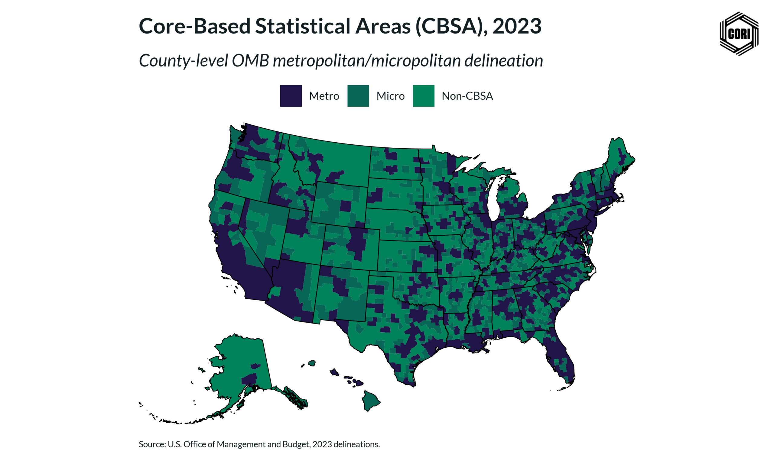
Used by: Office of Management and Budget (OMB)
Geography: County
This definition groups counties and county equivalents around an urban population core and nearby areas that are socially and economically connected to that core through commuting. CBSAs include Metropolitan Statistical Areas, which have an urban core of 50,000 or more people, and Micropolitan Statistical Areas, which have an urban core of at least 10,000 but less than 50,000 people. Areas outside of Metropolitan and Micropolitan Statistical Areas are classified as nonmetropolitan. Learn more.
Rural Urban Commuting Area (RUCA) codes
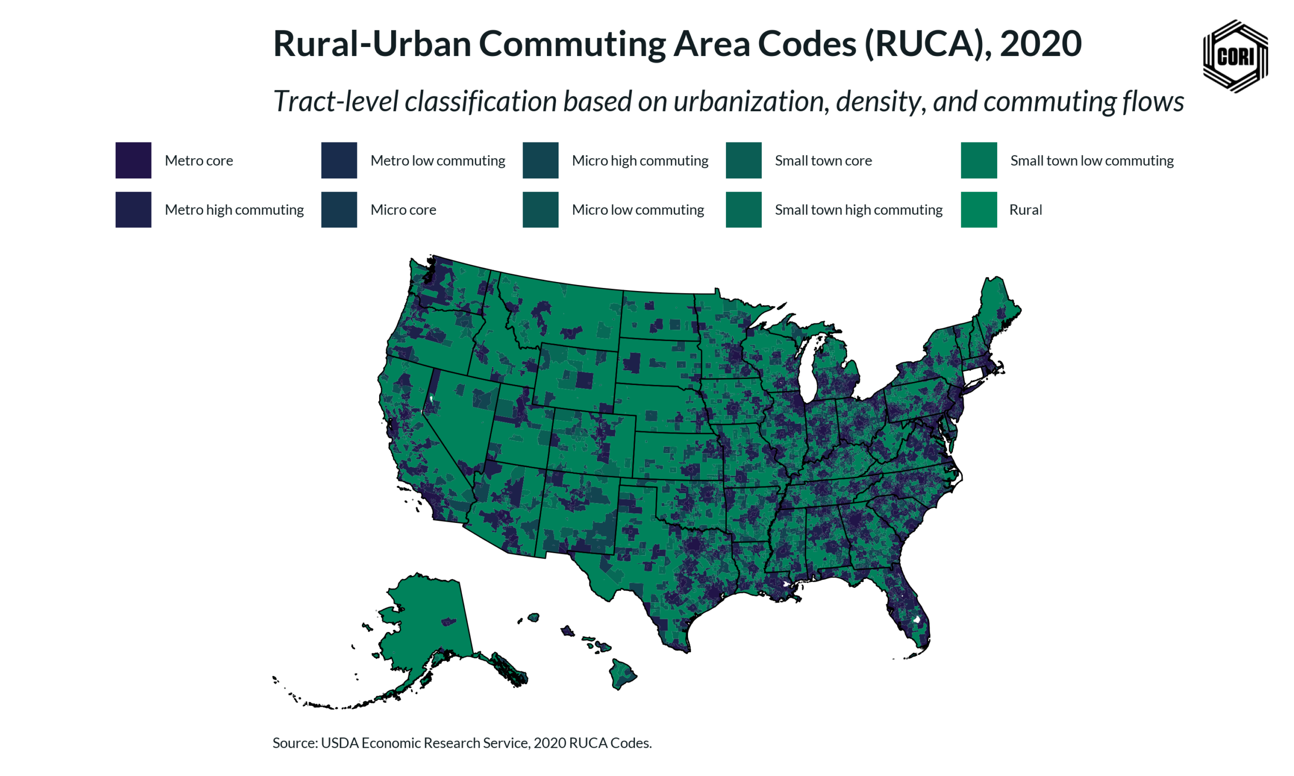
Used by: USDA – Economic Research Service (ERS)
Geography: Census Tract & Zip Code
Rural Urban Commuting Area (RUCA) codes classify the urban-rural spectrum at a more detailed geographic level than county-based definitions. RUCA codes use population density, urbanization, and commuting patterns to identify metropolitan, micropolitan, small town, and rural areas, as well as the degree to which places are economically connected to larger population centers. These codes are especially useful for identifying rural communities within large metropolitan counties. Learn More.
Rural Urban Continuum Codes (RUCCs)
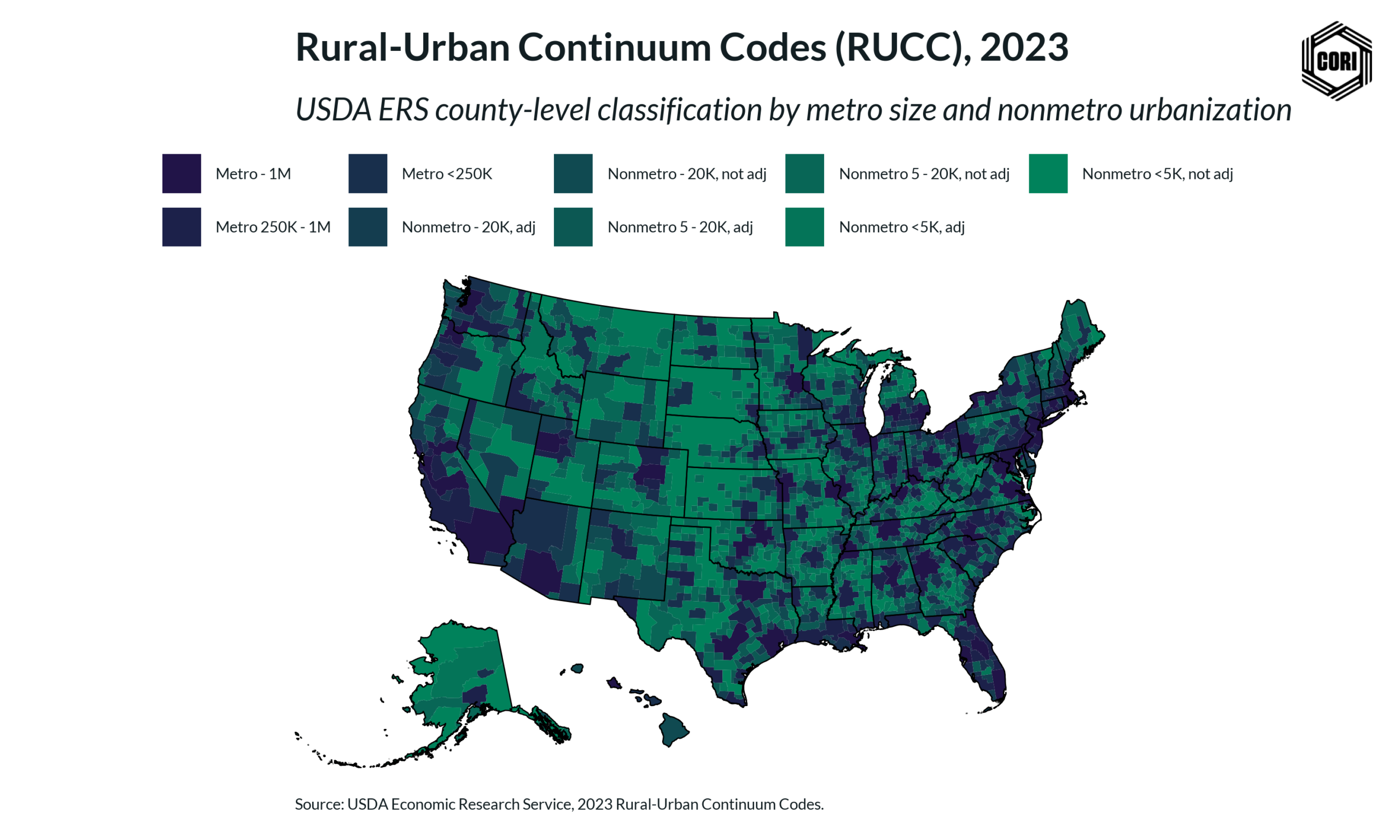
Used by: USDA – Economic Research Service (ERS)
Geography: County
Rural Urban Continuum Codes (RUCCs) classify counties into nine categories across the rural-urban spectrum. The codes distinguish metropolitan counties by the population size of their metro area and nonmetropolitan counties by their degree of urbanization and adjacency to a metropolitan area. This definition provides a more detailed way to analyze county-level differences beyond a simple metro/nonmetro classification. Learn more.
Urban Influence Codes (UICs)
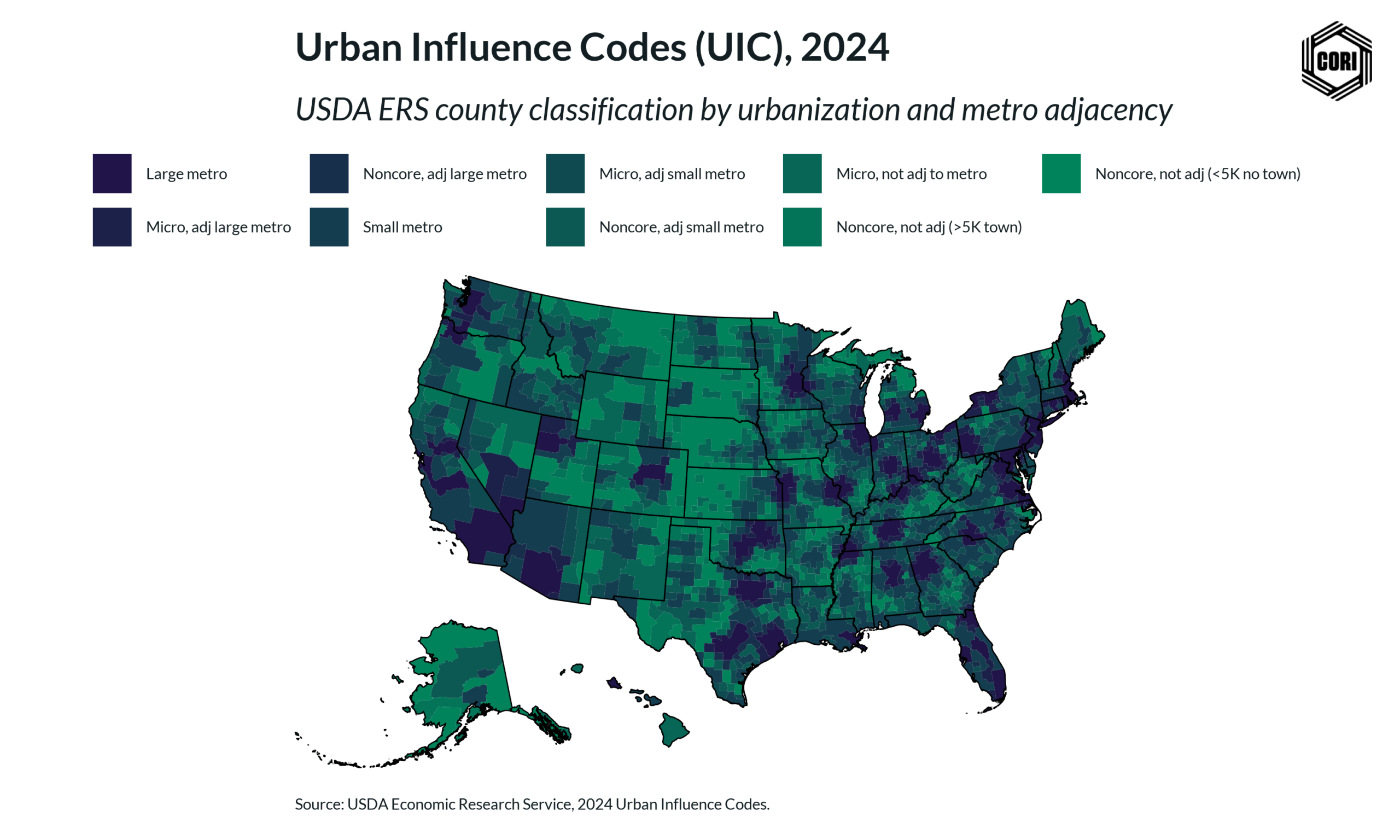
Used by: USDA – Economic Research Service (ERS)
Geography: County
Urban Influence Codes (UICs) classify counties and county equivalents based on their relationship to nearby urban areas. The current 2024 version uses nine categories that group counties by large metro influence, small metro influence, or nonadjacency to a metro area. The codes incorporate metropolitan, micropolitan, and noncore counties, making them useful for understanding how proximity to urban centers may shape economic, social, and policy outcomes in rural places. Learn more.
NCHS Urban-Rural Classification Scheme for Counties
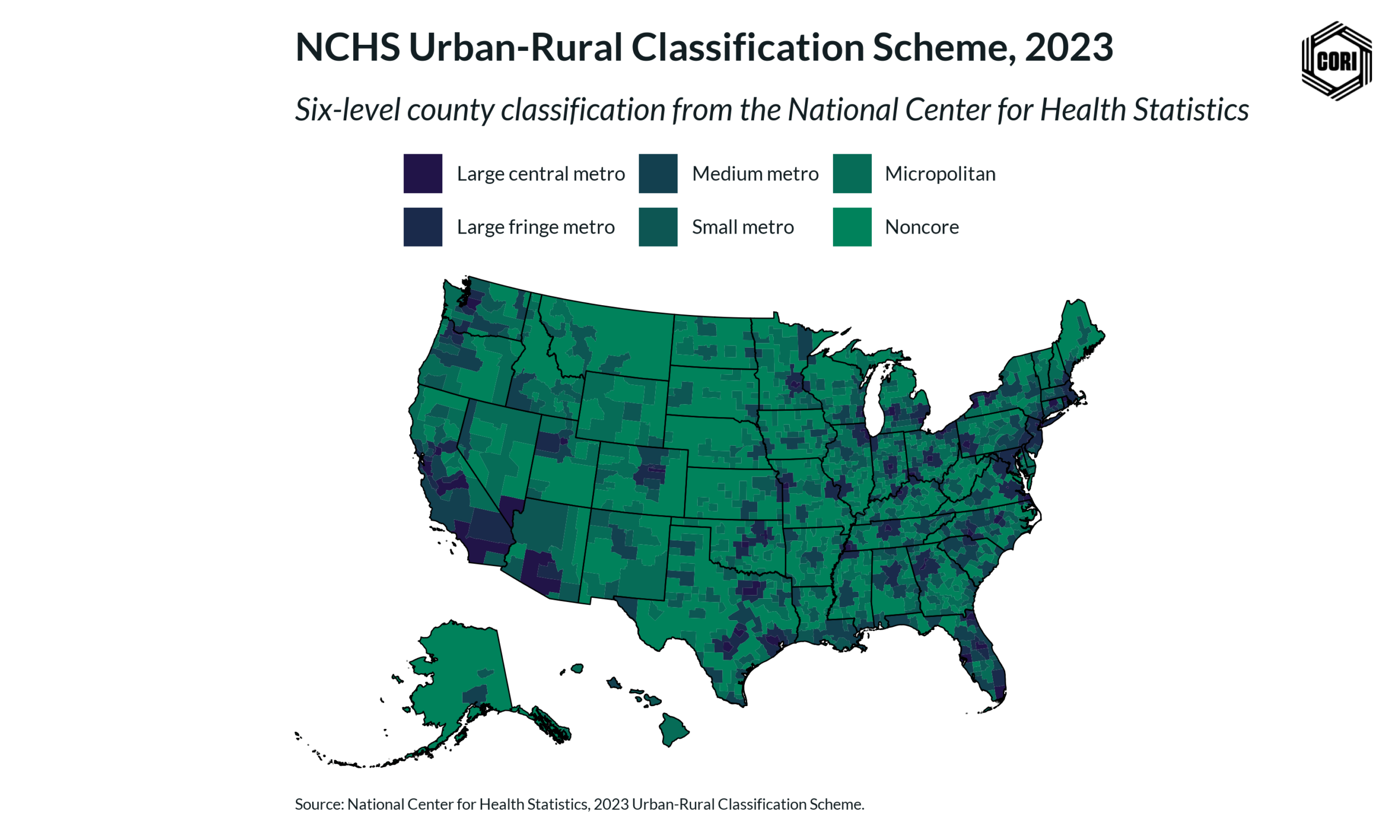
Used by: National Center for Health Statistics (NCHS)
Geography: County
This definition classifies U.S. counties and county equivalents into six urban-rural categories based on their level of urbanization. The scheme includes four metropolitan categories—large central metro, large fringe metro, medium metro, and small metro—and two nonmetropolitan categories: micropolitan and noncore. Researchers and policymakers use it to compare health outcomes and other measures across the urban-rural spectrum.
How CORI Frames Rural
At the Center on Rural Innovation, we define rural in a way that helps focus our work on the communities most affected by the rural opportunity gap and most ready to shape a stronger economic future. CORI’s definition includes both communities in nonmetro counties and communities within metro counties that are meaningfully isolated from larger urban centers. This approach recognizes that rural is not only a county designation; it is also about access, proximity, economic connection, and whether a place has been left out of the growth and investment seen elsewhere. We use this definition to guide where we partner, invest, conduct research, and support rural leaders working to build more inclusive and resilient economies.
CORI Rural Definition
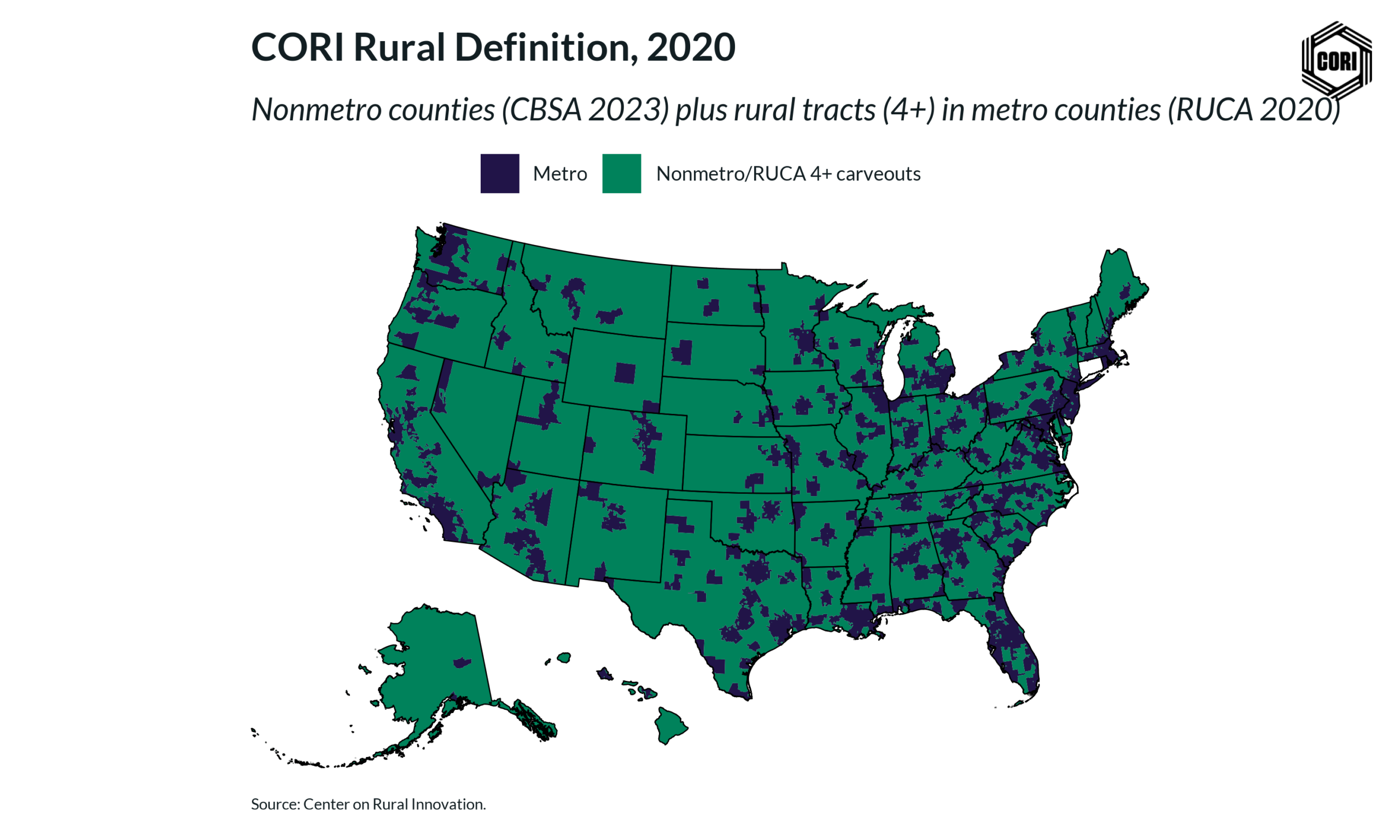
Geography: County & Census Tract
This definition identifies rural communities using both county- and census tract-level measures. CORI includes communities in nonmetropolitan counties (CBSAs), which generally have population centers of fewer than 50,000 people and are not suburbs, as well as communities located within metropolitan counties that are isolated from the larger city in that county (RUCA 4 or higher). This definition helps CORI focus its work on places most affected by the rural opportunity gap and where targeted investment, research, and partnership can help unlock long-term economic potential.